UPDATES:
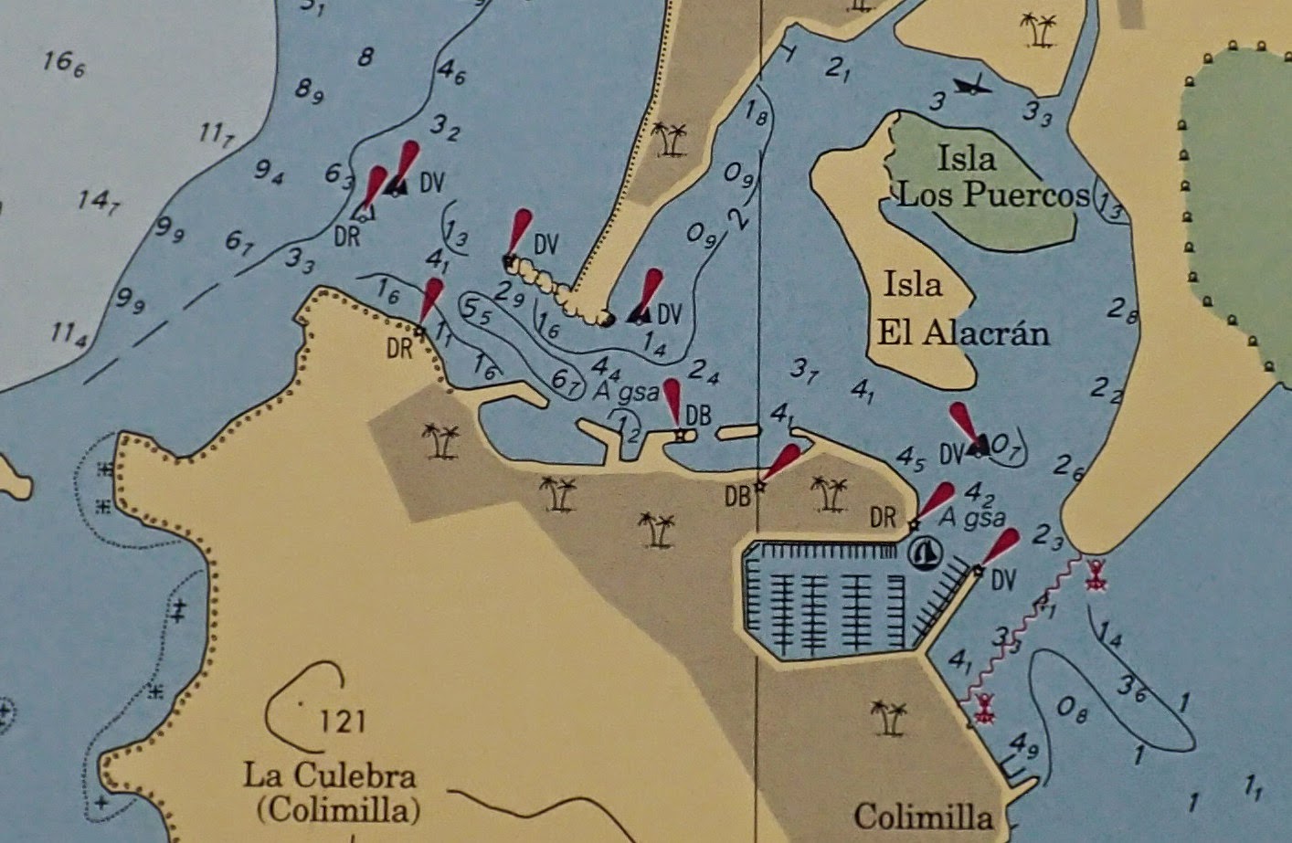
- January/October 2018: Mexico SEMAR has issued a NEW, DETAILED chart for Bahia de La Paz. Shows details of the islands.
We have heard many cruisers say -- and
many others' blog posts state -- that "Mexican charts are inaccurate and based on surveys from the 1800s". This oft-repeated statement is based on incorrect and/or out-dated information -- in many areas of Mexico, it is patently false. (If it were true, why is there excellent chart detail available for the marina areas of Puerto Los Cabos or Cabo San Lucas, two man-made ports that did not exist in the 1800s, or even in the 1960s?) Of course, one will definitely have very out-dated charts if one relies on (i) DMA charts (e.g., "
Chartbooks" based on DMA charts), (ii) CM-93 vector charts, and/or (iii) electronic chart cards from C-Map or Navionics that have not been kept updated (e.g., from 2010)
As noted in our July 2014 post, official nautical charts are available in paper and electronic (Raster or Vector) formats from the Secretaria de Marina Armada de Mexico (SEMAR). Full information is available on the
SEMAR "Hidrografia" webpage.
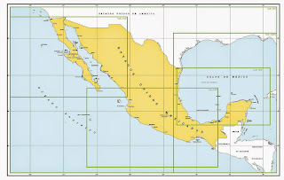 |
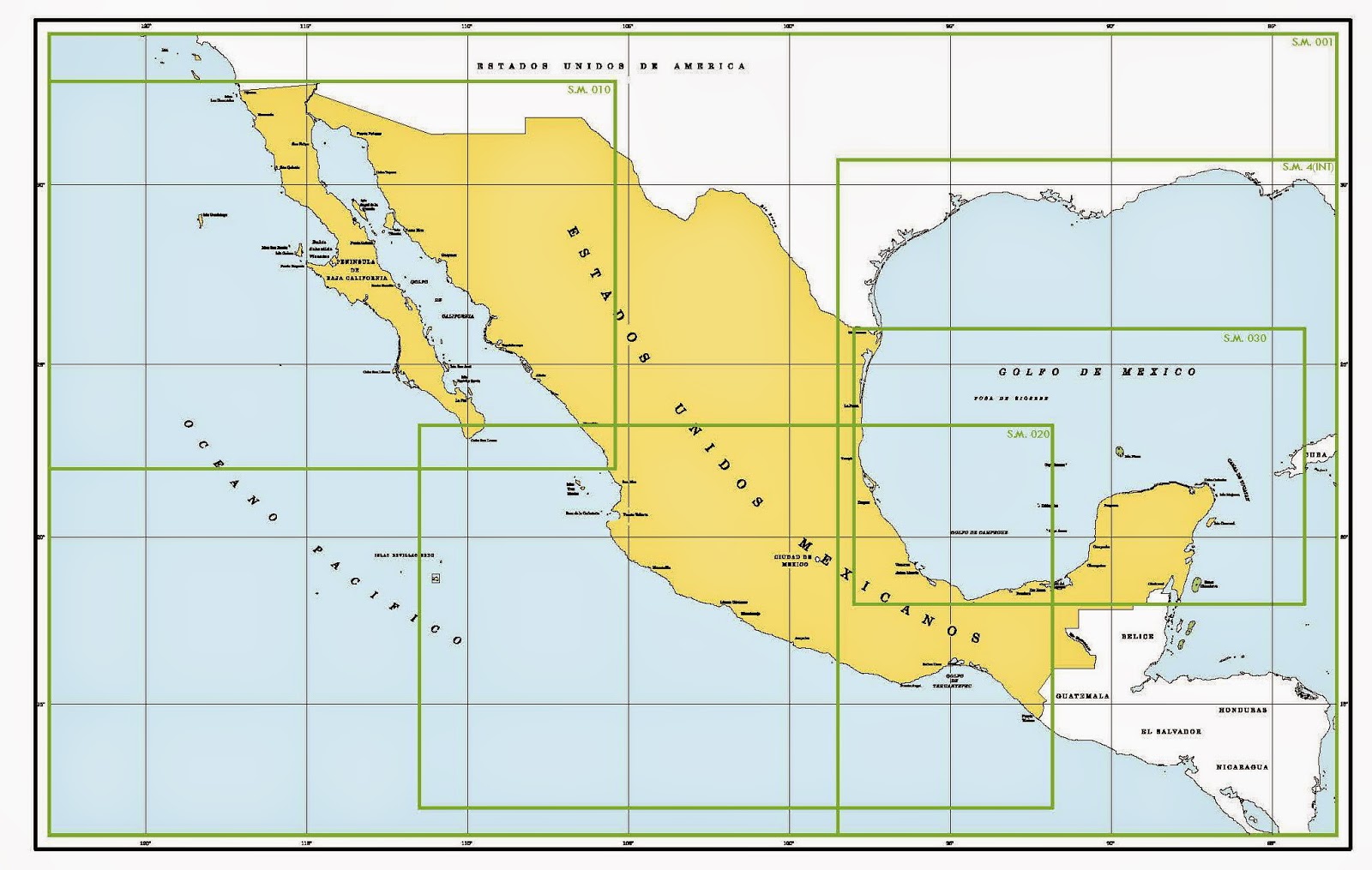
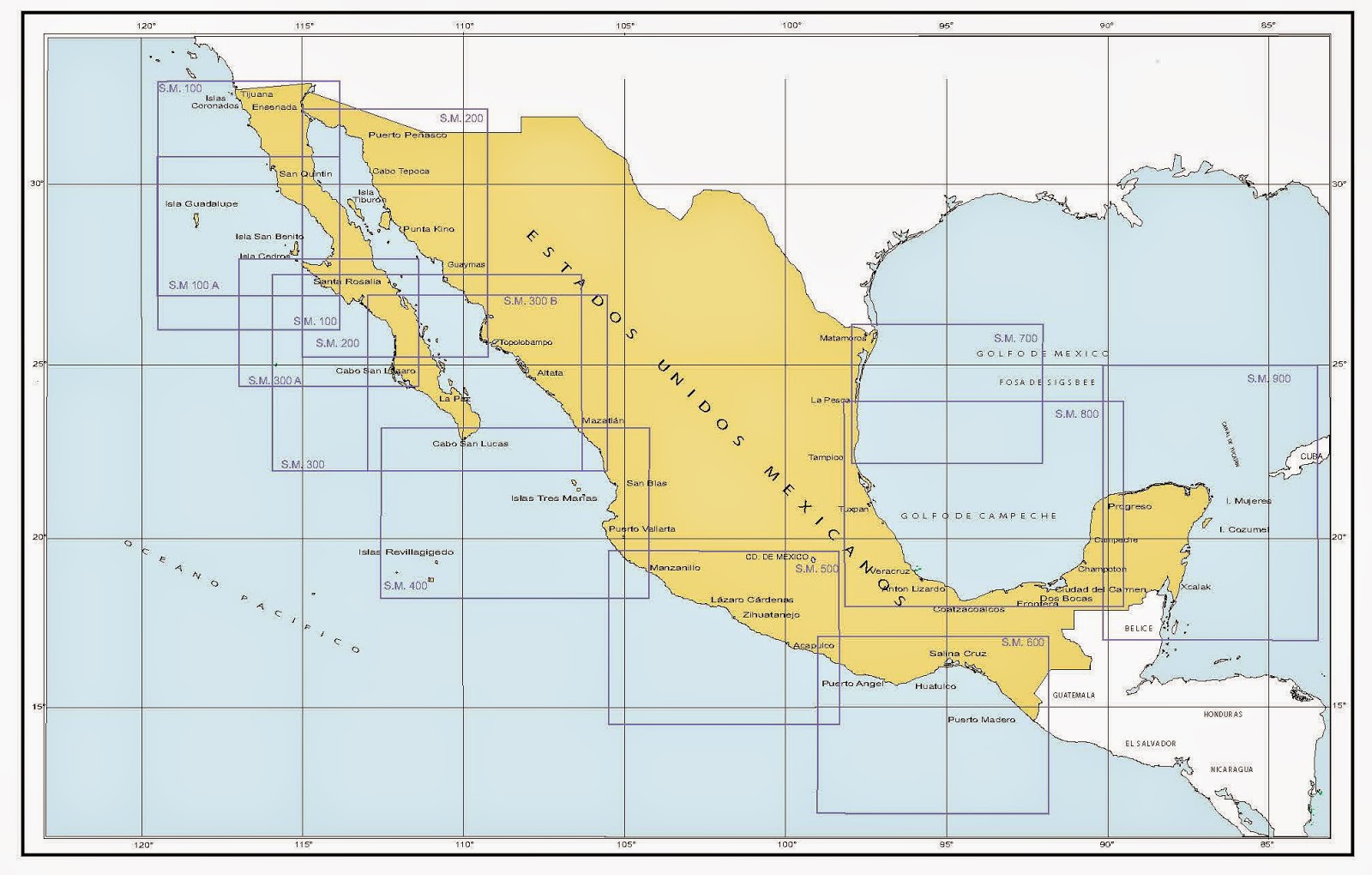
| SEMAR small-scale "region" Charts |
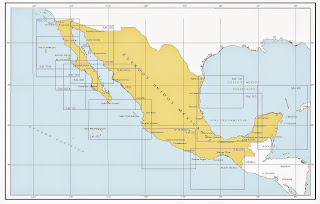 |
| SEMAR "general" charts |
 |
| SEMAR detailed charts for the Pacific coast (2015 catalog): many areas require detailed charts |
 |
| Overall plan for Detailed charts: many still to come |
Over the past 20 years, Mexico has produced and updated many new nautical charts, and these are available from SEMAR.
Nevertheless, there remain many areas without large-scale detailed charts. Unfortunately, for the cruiser planning on visiting Mexico by boat, it does not appear SEMAR provides their nautical charts in packages, such as "Pacific Mexico Charts" -- one would have to purchase each chart (electronic or paper format) individually. At 413 pesos (C$33 or US$27, May 2015)
per chart, the total cost for the Pacific coast would be very expensive.
Update 2022: Complete
INEXPENSIVE sets of SEMAR vector charts are now available from O-Charts for use in OpenCPN. See: http://sailing-pelagia.blogspot.com/2022/03/the-best-chart-package-for-pacific.html?m=1
In contrast,
commercial charting products covering the whole Pacific coast of Mexico are available at a reasonable cost, including C-MAP and Navionics. ^^
We purchased our first C-MAP chart card in 2011. Reviewing this chart card before leaving for Mexico, we learned early that the
C-MAP charts lacked detail for many large areas of Mexico. When we finally cruised from Cabo to La Paz, we found the C-MAP card
lacked details (and GPS accuracy) lacking for the majority of the
journey up to La Paz (including Bahia Los Frailes and Ensenada Los
Muertos) and the islands north of La Paz (Isla Espiratu Santo & Isla
Partida). The entrance to La Paz, however, had excellent detail. We also learned that each year, C-MAP chart updates included more detail for some (but certainly not all) areas we planned to visit in Mexico. For example, in 2011, the C-MAP card chart did not show the marina complex of Puerto Los Cabos (San Jose del Cabo). By 2013, the CMAP card had been updated, with full detail for Puerto Los Cabos.
C-MAP updates their charts on a regular basis -- twice annually -- but sometimes they seem slow to catch up with SEMAR. For example, SEMAR produced a chart for Altata (on the mainland side of the Sea of Cortez) in September 2010, but C-MAP first included this information in 2014. SEMAR produced a detailed chart of San Blas in 2006; C-MAP did not significantly update their detail on San Blas until 2014. SEMAR produced charts of Isla Espiratu Santo and of the San Lorenzo channel in 2009; as of May 2014, the detailed information in these charts has not been updated on C-MAP (or Navionics) charts. (On the other hand,
often C-MAP charts are updated quickly: for example, the May 2014 C-MAP had an up-to-date detailed chart for Loreto that SEMAR published approximately 6 months earlier in 2013 as well as the two San Felipe charts SEMAR produced October 2013.) *
Updated C-MAP (and Navionics) electronic charts use the data from the official Mexican (SEMAR) charts. The comparisons below (of C-MAP and official SEMAR charts) show the detail in these charts. Both charts are reasonably accurate, although oddly, the C-MAP charts often tend to show fewer depth soundings.
(In the comparisons below, the C-MAP charts were blown up to get the maximum detail re: depth soundings; an attempt was made to keep chart scales/sizes approximately equal -- not always successfully.)
Depths are in meters; Colour shading of C-MAP depends on chartplotter type and settings.
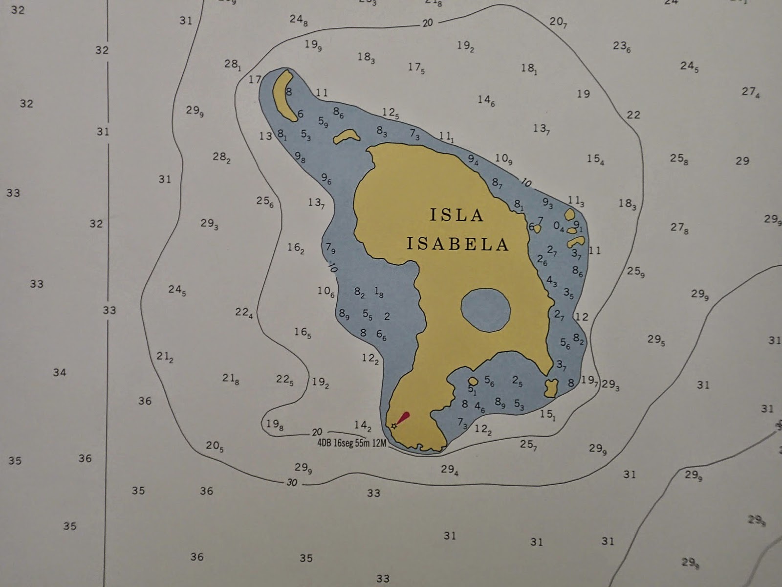
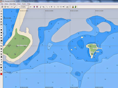
Isla Isabela:
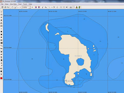 |
| Isla Isabela: CMAP 2014 |
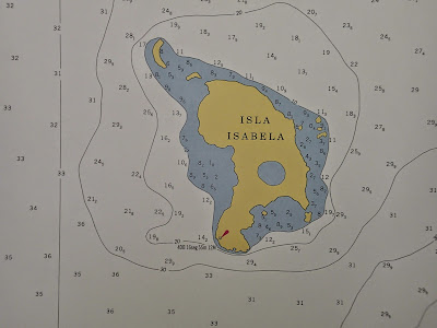 |
| Isla Isabela: SEMAR |
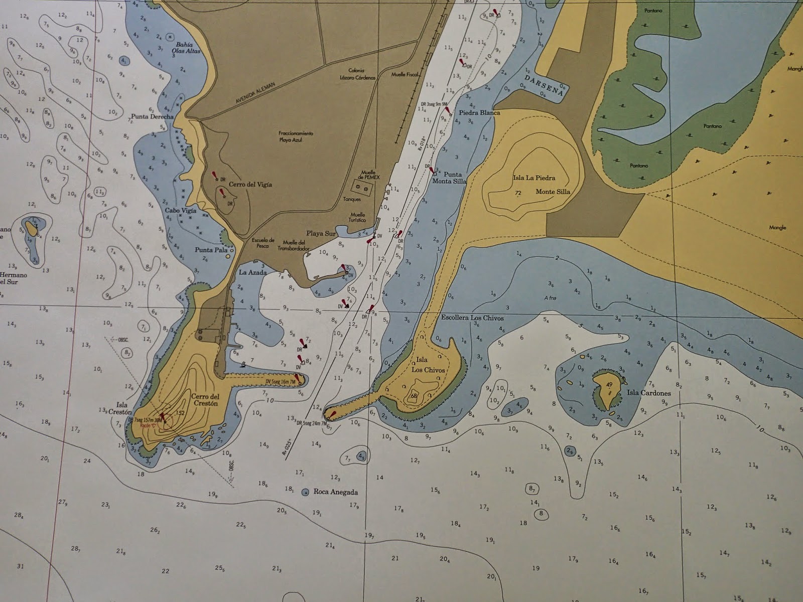
Isla Cardones/Stone Island anchorage (Mazatlan):
 |
| Isla Cardones/Stone Island anchorage: C-MAP 2014 |
 |
| Isla Cardones/Stone Island anchorage: SEMAR |
Puerto Vallarta (old port):
 |
| Puerto Vallarta: C-MAP 2014 |
 |
| Puerto Vallarta: SEMAR |
Barra de Navidad (lagoon entrance):
 |
| Barra de Navidad: C-MAP 2014 |
 |
| Barra de Navidad: SEMAR |
SEMAR Mexico does produce accurate up-to-date charts. (However,
large-scale detailed charts are still being produced and are not yet available for all areas -- see above.) Unfortunately, these official charts are costly (and a little difficult to obtain). C-MAP charts are reasonably priced (for the whole coast of Mexico, and beyond) and are easy to obtain. However, data in many areas are low in detail and accuracy (and, as vector charts, this does not become clear until one zooms in on an area). Nevertheless, C-MAP bases
updates on the updated and new SEMAR official charts.
We have found the updated areas of C-MAP Mexico charts to be reasonably accurate. It is therefore important to obtain regular C-MAP updates (easily done through "
Club Jeppesen")
.
^^
Updated charts notwithstanding, a prudent mariner never relies solely on charts. If one didn't know this before while navigating waters in Canada and/or the USA, one quickly learns this when cruising in Mexico (where many areas still lack detailed charts). ALL sources of information available must used.
*
Navionics: We purchased Navionics charts (Android-based) in 2014; we therefore have not had as much experience with these charts.
Importantly, at least for the Sea of
Cortez, the Navionics charts do not seem as up-to-date as the C-MAP charts. For example, detailed charts of Loreto, San Felipe, Altata and San Blas, which are up-to-date on the May 2014 C-MAP card, were not up-to-date on the Android Navionics charts (as of May 27, 2015). See our 2016: http://sailing-pelagia.blogspot.ca/2016/05/mexico-charts-c-map-versus-navonics.html
Although the price of Navionics charts for the Android (and IPad) is
relatively inexpensive (and the base
software free... however, in 2019, Navionics tripled their chart prices!), our Android version of Navionics requires us to select
areas and then download (or update) charts while on WiFi -- we
find this to be a pain. Further, the Navionics Android app does not allow import/export of waypoints/routes. Also, we are not
fans of Navionics' provision of "community-based" chart info (e.g., users
can input location of rocks etc.), as there is no verification of the accuracy of
this input. We have found many community-based additions (rocks, anchorages, etc) to be incorrect. Many are helpful, but if some are wrong, how does one know which to trust? Also, there can be so many community-based additions, it is hard to read chart (take a look at "Caleta Partida" in the Islands above La Paz: it's a mess because of so many community edits.